Environmental Mapping


Environmental Mapping Services For Sustainable Land Management in Atlantic Canada
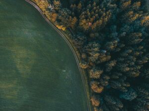
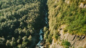
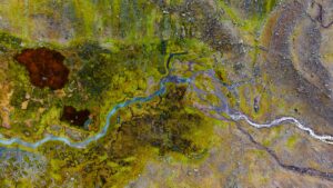
AeroSeed’s environmental mapping services use state-of-the-art drone technology to capture precise data for natural resource management and environmental monitoring across Nova Scotia, New Brunswick, and PEI. With high-resolution imaging and advanced sensors, our drones create detailed, accurate maps that reveal key environmental insights, such as vegetation health, soil quality, and water flow. This comprehensive data collection supports conservation efforts, land use planning, and environmental impact assessments, helping organizations make informed decisions that promote sustainable practices and ecosystem preservation.
By covering large areas efficiently and accessing remote or challenging terrain, drone mapping provides a safer, faster, and more cost-effective solution for environmental surveys. Our mapping services enable government agencies, conservation groups, and researchers to monitor changes over time, detect environmental degradation, and assess biodiversity across various ecosystems. With AeroSeed’s drone mapping solutions, clients gain a deeper understanding of the Atlantic Canada landscape, empowering them to take proactive measures in environmental protection and sustainable development initiatives.
Environmental Mapping with Drones
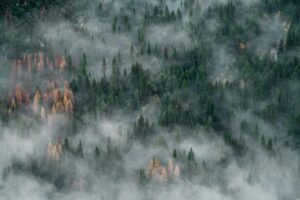
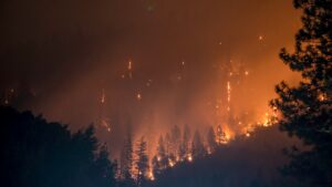
Drones are revolutionizing environmental mapping by providing fast, accurate, and high-resolution data that enables detailed visualization of complex landscapes. Equipped with technologies like LiDAR, multispectral imaging, and high-resolution cameras, drones can capture topography, vegetation types, soil conditions, and water features with exceptional precision. This data helps environmental professionals create accurate maps for areas that are otherwise difficult to reach, such as wetlands, mountainous regions, and coastal zones. Drone mapping can identify subtle changes in the environment, detect erosion patterns, and assess biodiversity, offering insights that support conservation efforts, land-use planning, and natural resource management. By covering large areas efficiently and with minimal disturbance, drones deliver cost-effective solutions for comprehensive environmental analysis and sustainable decision-making in regions like Nova Scotia, New Brunswick, and PEI.
Frequently Asked Questions
What is environmental mapping, and how does it work?
Environmental mapping involves using drones and advanced imaging technologies, such as LiDAR and multispectral sensors, to create highly detailed maps of landscapes and ecosystems. These maps provide valuable data on factors like vegetation health, soil composition, water bodies, and land topography, helping with environmental assessments, conservation efforts, and sustainable land management.
How can drones improve environmental mapping?
Drones offer a cost-effective, efficient, and minimally invasive solution for mapping large or remote areas. With drones, we can capture high-resolution images and gather extensive data quickly, covering difficult-to-reach terrain such as wetlands, forests, and mountainous regions in Nova Scotia, New Brunswick, and PEI. This data supports a deeper understanding of environmental conditions without disturbing sensitive ecosystems.
What types of projects benefit from drone-based environmental mapping?
Projects that benefit include wildlife habitat monitoring, land-use planning, erosion assessment, forestry management, and climate impact studies. Environmental mapping is also valuable for tracking changes over time, allowing organizations to observe trends in natural resource availability, vegetation health, and ecosystem changes.
What kinds of data can environmental mapping drones capture?
Our drones capture various data types, including topographic and vegetation data, soil and water health indicators, and thermal data for detecting heat sources or stressed vegetation. This comprehensive data supports a wide range of environmental studies, from mapping forest density to assessing biodiversity in aquatic ecosystems.
How frequently should environmental mapping be conducted?
The frequency depends on the project’s objectives. For instance, land-use planning may only require a single survey, while monitoring erosion or tracking ecosystem health may benefit from seasonal or annual mapping. Frequent mapping can help detect environmental changes, allowing for timely interventions when needed.
What is the difference between environmental mapping and environmental monitoring?
Environmental mapping provides a snapshot of a landscape, capturing details like vegetation types, soil conditions, and terrain features. Environmental monitoring, however, involves tracking specific environmental factors over time to detect changes, such as shifts in biodiversity, water quality, or vegetation health. Both mapping and monitoring play essential roles in managing and protecting natural resources effectively.
Still have a question?
If you have any other queries, feel free to reach out to us. Our knowledgeable team is here to help!